Gwalior
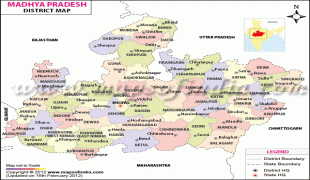
Gwalior is a major city in the central Indian state of Madhya Pradesh; it lies in northern part of Madhya Pradesh and is one of the Counter-magnet cities. Located 343 km south of Delhi, the capital city of India, 120 km from Agra and 414 km from Bhopal, the state capital, Gwalior occupies a strategic location in the Gird region of India. The historic city and its fortress have been ruled by several historic Indian kingdoms. From the Kachchhapaghatas in the 10th century, Tomars in the 13th century, it was passed on to the Mughal Empire, then to the Maratha in 1754, and the Scindia dynasty of Maratha Empire in the 18th century. In April 2021, It was found that Gwalior had the best air quality index (AQI 152) amongst the 4 major cities in Madhya Pradesh.
Besides being the administrative headquarters of Gwalior district and Gwalior division, Gwalior has many administrative offices of the Chambal division of northern Madhya Pradesh. Several administrative and judicial organisations, commissions and boards have their state and national headquarters situated in the city.
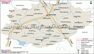
Gwalior was the winter capital of the state of Madhya Bharat which later became a part of the larger state of Madhya Pradesh. Prior to Indian independence on 15 August 1947, Gwalior remained a princely state of the British Raj with the Scindia as the local rulers. High rocky hills surround the city from all sides, on the north it just forms the border of the Ganga- Yamuna Drainage Basin. The city however is situated in the valley between the hills. Gwalior's metropolitan area includes Gwalior city centre, Morar Cantonment, Lashkar Gwalior (Lashkar Subcity), Maharaj Bada, Phool Bagh, and Thatipur.
Gwalior was one of the major locations of rebellion during the 1857 uprising. Post-independence, Gwalior has emerged as an important tourist attraction in central India while many industries and administrative offices came up within the city. Before the end of the 20th century it became a million plus agglomeration and now it is a metropolitan city in central India. Gwalior is surrounded by industrial and commercial zones of neighbouring districts (Malanpur – Bhind, Banmore – Morena) on all three main directions.
Gwalior has been selected as one of the hundred Indian cities to be developed as a smart city under PM Narendra Modi's flagship Smart Cities Mission.
According to legend, Gwalior was founded in 8 CE after a local chieftain, Suraj Sen who was cured of leprosy from a drink given to him by a holy man called Gwalipa. Suraj subsequently set up a town and fort and named them after Gwalipa.
The earliest historical record found at Gwalior is the Gwalior inscription of the Alchon Hun ruler Mihirakula. It describes Mihirakula's father Toramana (493-515) as "a ruler of the earth, of great merit, who was renowned by the name of the glorious Tôramâna; by whom, through (his) heroism that was specially characterized by truthfulness, the earth was governed with justice", and his Mihirakula as "the lord of the earth" as of 520 CE.
Around the 9th century, the Gurjara-Pratihara dynasty controlled Gwalior and during their rule, they constructed the Teli ka Mandir temple. The Kachchhapaghata dynasty ruled the area c.950 –c.1192 CE, leaving remarkable architectural works such as the Sasbahu Temple. In 1021, Gwalior was attacked by forces led by Mahmud Ghazni but they were repelled.
In 1231 Iltutmish, ruler of the Mamluk dynasty of the Delhi Sultanate, captured Gwalior after an 11-month-long effort and from then till the 13th century it remained under Muslim rule. In 1375, Raja Veer Singh was made the ruler of Gwalior and he founded the rule of the Tomar clan. During those years, Gwalior saw its golden period.
The Jain Sculptures at Gwalior Fort were built under Tomar rule. Man Singh Tomar made his dream palace, the Man Mandir Palace which is now a tourist attraction at Gwalior Fort. Babur described it as "the pearl in the necklace of forts of India and not even the winds could touch its masts". The daily light and sound show organised there apprise about the history of the Gwalior Fort and Man Mandir Palace. By the 15th century, the city had a noted singing school which was attended by the prominent figure of Hindustani classical music, Tansen. After death of Mughal Emperor Aurangzeb the Jat ruler Bhim Singh Rana captured Gwalior from Mughals. Later in the 1830s, the Scindias captured Gwalior and it remained a princely state during the period of British rule.
Besides being the administrative headquarters of Gwalior district and Gwalior division, Gwalior has many administrative offices of the Chambal division of northern Madhya Pradesh. Several administrative and judicial organisations, commissions and boards have their state and national headquarters situated in the city.
Gwalior was the winter capital of the state of Madhya Bharat which later became a part of the larger state of Madhya Pradesh. Prior to Indian independence on 15 August 1947, Gwalior remained a princely state of the British Raj with the Scindia as the local rulers. High rocky hills surround the city from all sides, on the north it just forms the border of the Ganga- Yamuna Drainage Basin. The city however is situated in the valley between the hills. Gwalior's metropolitan area includes Gwalior city centre, Morar Cantonment, Lashkar Gwalior (Lashkar Subcity), Maharaj Bada, Phool Bagh, and Thatipur.
Gwalior was one of the major locations of rebellion during the 1857 uprising. Post-independence, Gwalior has emerged as an important tourist attraction in central India while many industries and administrative offices came up within the city. Before the end of the 20th century it became a million plus agglomeration and now it is a metropolitan city in central India. Gwalior is surrounded by industrial and commercial zones of neighbouring districts (Malanpur – Bhind, Banmore – Morena) on all three main directions.
Gwalior has been selected as one of the hundred Indian cities to be developed as a smart city under PM Narendra Modi's flagship Smart Cities Mission.
According to legend, Gwalior was founded in 8 CE after a local chieftain, Suraj Sen who was cured of leprosy from a drink given to him by a holy man called Gwalipa. Suraj subsequently set up a town and fort and named them after Gwalipa.
The earliest historical record found at Gwalior is the Gwalior inscription of the Alchon Hun ruler Mihirakula. It describes Mihirakula's father Toramana (493-515) as "a ruler of the earth, of great merit, who was renowned by the name of the glorious Tôramâna; by whom, through (his) heroism that was specially characterized by truthfulness, the earth was governed with justice", and his Mihirakula as "the lord of the earth" as of 520 CE.
Around the 9th century, the Gurjara-Pratihara dynasty controlled Gwalior and during their rule, they constructed the Teli ka Mandir temple. The Kachchhapaghata dynasty ruled the area c.950 –c.1192 CE, leaving remarkable architectural works such as the Sasbahu Temple. In 1021, Gwalior was attacked by forces led by Mahmud Ghazni but they were repelled.
In 1231 Iltutmish, ruler of the Mamluk dynasty of the Delhi Sultanate, captured Gwalior after an 11-month-long effort and from then till the 13th century it remained under Muslim rule. In 1375, Raja Veer Singh was made the ruler of Gwalior and he founded the rule of the Tomar clan. During those years, Gwalior saw its golden period.
The Jain Sculptures at Gwalior Fort were built under Tomar rule. Man Singh Tomar made his dream palace, the Man Mandir Palace which is now a tourist attraction at Gwalior Fort. Babur described it as "the pearl in the necklace of forts of India and not even the winds could touch its masts". The daily light and sound show organised there apprise about the history of the Gwalior Fort and Man Mandir Palace. By the 15th century, the city had a noted singing school which was attended by the prominent figure of Hindustani classical music, Tansen. After death of Mughal Emperor Aurangzeb the Jat ruler Bhim Singh Rana captured Gwalior from Mughals. Later in the 1830s, the Scindias captured Gwalior and it remained a princely state during the period of British rule.
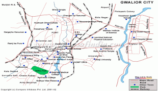
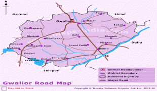
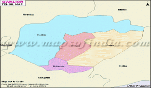
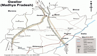
Map - Gwalior
Map


Country - India
 |
 |
| Flag of India | |
Modern humans arrived on the Indian subcontinent from Africa no later than 55,000 years ago. Their long occupation, initially in varying forms of isolation as hunter-gatherers, has made the region highly diverse, second only to Africa in human genetic diversity. Settled life emerged on the subcontinent in the western margins of the Indus river basin 9,000 years ago, evolving gradually into the Indus Valley Civilisation of the third millennium BCE. By, an archaic form of Sanskrit, an Indo-European language, had diffused into India from the northwest. (a) (b) (c), "In Punjab, a dry region with grasslands watered by five rivers (hence ‘panch’ and ‘ab’) draining the western Himalayas, one prehistoric culture left no material remains, but some of its ritual texts were preserved orally over the millennia. The culture is called Aryan, and evidence in its texts indicates that it spread slowly south-east, following the course of the Yamuna and Ganga Rivers. Its elite called itself Arya (pure) and distinguished themselves sharply from others. Aryans led kin groups organized as nomadic horse-herding tribes. Their ritual texts are called Vedas, composed in Sanskrit. Vedic Sanskrit is recorded only in hymns that were part of Vedic rituals to Aryan gods. To be Aryan apparently meant to belong to the elite among pastoral tribes. Texts that record Aryan culture are not precisely datable, but they seem to begin around 1200 BCE with four collections of Vedic hymns (Rg, Sama, Yajur, and Artharva)."
Currency / Language
| ISO | Currency | Symbol | Significant figures |
|---|---|---|---|
| INR | Indian rupee | ₹ | 2 |
| ISO | Language |
|---|---|
| AS | Assamese language |
| BN | Bengali language |
| BH | Bihari languages |
| EN | English language |
| GU | Gujarati language |
| HI | Hindi |
| KN | Kannada language |
| ML | Malayalam language |
| MR | Marathi language |
| OR | Oriya language |
| PA | Panjabi language |
| TA | Tamil language |
| TE | Telugu language |
| UR | Urdu |